I was blown away when I saw Scott Reinhard’s work combining old print maps with 3D rendering on This Is Colossal. I set out to try to create something similar, and after a lot of trial and error, came up with something that’s not as sophisticated, but still produces a decent looking map.
I created these maps with public domain data from the USGS, NOAA state GIS repositories and free HDRIs from HDRI-SKIES and HDRIHAVEN. Maps are made using QGIS, Aerialod, GIMP and Just Color Picker.
You may download and use these high resolution map images under the Creative Commons Non-Commercial Share and Share Alike License. Wal-Mart makes a surprisingly good quality and cheap poster sized print.
Maps by Location
sun path model
path model
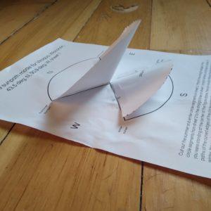
Here is a link to a template so you can make your own solstice sun path model for latitudes between 30 and 60 degrees.